MISSION ACCOMPLISHED!!!

I do know I have 7 hikes to update here, as the final days of the year have been a mad frenzy, but…

I DID IT!!!! I COMPLETED 52 TREKS IN 2012!!!!!!

munson creek falls, cascade head, roads end, drift creek falls 083VICTORY!!!!!

My 52nd trek was completed at Drift Creek Falls on December 31st, 2012.

Updates on my final hikes to come very soon.  Happy trails everyone!

Posted in Uncategorized | Tagged , , | 3 Comments

Trek #45: Kelley Point Park

Kelley Point Park is, hands down, the most ominous trek of my year. Congrats to this trail for freaking me the hell out. Have you ever read the Scary Stories books by Alvin Schwartz? This whole trail could be illustrated for a story about a hiker who encounters terrible things in the woods.

kelley point park, smith and bybee lakes, whitaker ponds loop 004
Where trolls live.

This is not, however, at the fault of the trail itself. Nestled at the westernmost tip of North Portland, I know this place must be quite pretty during the day, instead of being gloomy as hell when I was there right before dawn broke. The park is surrounded by both the Columbia and Willamette Rivers, which during the day probably makes for a gorgeous riverside trek, but in the predawn hours, the fog is rolling heavy off the water and the winter-bare trees look straight out of an episode of GRIMM. It didn’t help that (not at all surprisingly) I was completely alone. After pulling into the lot and being the only car there, the further I walked onto the path, the more I felt I was walking deeper into some creepy Narnia. I will, however, give this trek 5 gold stars for a full emotional experience. All my senses were heightened for sure.

As I’ve stated several times previously, time is a massive factor in how I’ve been able to plan my hikes this year, and this was the only time of day I was able to get out and do this one, despite it being a less than ideal time for a trek. That said, I am absolutely coming back in the summer, when the sun is shining brightly, the trees are lush with leaves, and the paths are populated with people, and compare photos. I bet this trek will have a 100% completely different feel to it.

In the meantime, if you’re shooting a low budget horror film, Kelley Point Park on a winter day just before dawn is exactly where you want to film your scenes.

This slideshow requires JavaScript.

Treks Down: 45, Treks to Go: 7

Posted in Uncategorized | Tagged , , , | Leave a comment

Trek #44: August Mountain Loop

August Mountain Loop is a 5 mile trail you can take either instead of or in addition to Shellburg Falls (click here to read about my Shellburg Falls trek).  While nearly all of my previous hikes have been filled with beauty or had at least one landmark to make it all worth it, I have to admit I found this trail to be rather underwhelming.

shellburg falls and august mountain trail 042Underwhelming might be harsh. Maybe just whelming.

Based on the numerous thin tire treads on the trail, I can tell August Mountain gets a good deal of mountain bikers. Maybe it’s more exciting if you’re whizzing over this path on two wheels. Some of the land the trail goes through has a lot of cut timber. Since I usually only take photos I think make for beautiful shots, I ended up not taking many of this trail. Actually, that above photo is probably the most appealing one, and it almost looks lush and inviting, but most of the trail was sparse and logged. I can’t fault my trailbook though, I decided to hike it while I was already out at Shellburg Falls, so I was going into this trek blindly (which is not wise, but the path was obvious).

I’d say if the day is nice and you’re looking for a little more exercise while already out at the falls, this could be a decent addition. Otherwise, I wouldn’t drive out here solely for the purpose of hiking this somewhat battered forest trail alone.  According to Portland Hikers Field Guide, there are supposed to be some very pretty flowers on the forest floor, so this trail is likely a much better spring and summer trek than a midwinter one when snow has covered the ground.

This slideshow requires JavaScript.

Treks Down: 44, Treks to Go: 8

Posted in Uncategorized | Tagged , , | Leave a comment

Trek #43: Shellburg Falls

Hiking to Shellburg Falls was, undoubtedly, one of the weirdest hikes I have ever trekked. The waterfall itself was absolutely breathtaking, as well as the area around it. But getting out there was not at all what I would ever expect from a hike listed in one of my trailbooks. For example, I never thought I’d have to gingerly step around sitting cows in the middle of a trail. Ever.

shellburg falls and august mountain trail 005I only felt comfortable photographing the ones further away, lest one get angry at me for capturing its soul and charging me. I actually don’t know anything about how cows work. For a hiker, I’m ridiculously urbane.

I’ll start with the drive itself. Shellburg Falls is located in the Santiam State Forest outside of Salem.  My trailbook (Pacific Northwest Hiking) led me to believe that Mehama, the town the hike is located, is so sparse you didn’t need road names, just vague markers to reach the trailhead (“Turn left at the blinking traffic light at the intersection.” There were actually several blinking traffic lights). After a series of confusing turns, I finally found the trailhead lot. There was only one other car there, belonging to two gentlemen whom were finishing their hike as I was starting mine. For the entirety of the hike I had the trail to myself. Myself and all the cows.

One thing that will become apparent if you didn’t already have a handy trailbook informing you, is that the land on both sides of the trail is privately owned land. This is obvious by the seemingly infinite number of “Private Property” and “No Trespassing” signs bolted to trees for the first 1.2 miles. This means you must remain on the trail, and only the trail (despite how inviting those meadows look), until you reach Shellburg Creek, lest the cows come charging after you with a bloodthirsty vengeance.  For some reason, even though I knew it was a designated trail, I kept feeling like I shouldn’t have been there. Like any moment Farmer Bob was going to come running out and telling me to get off his land.

Once at the creek, everything about the trail begins to feel like a familiar waterfall hike. You’re greeted by Lower Shellburg Falls, a lovely little 40 ft. waterfall that rushes underneath you to the continuing creek below. After you turn left up a set of wooden stairs, the trail becomes a narrow dirt path which follows Shellburg Creek all the way to Shellburg Falls. I was delighted to find that you can walk behind the falls, much like my favorites at Silver Falls State Park and Tunnel Falls at Eagle Creek.

shellburg falls and august mountain trail 017shellburg falls and august mountain trail 026The trail then continues up a series of switchbacks. I was pretty excited to find some snow on the trail. For some reason I hadn’t been expecting it.

shellburg falls and august mountain trail 034 shellburg falls and august mountain trail 037Winter Wonderland!


Eventually you’ll find yourself at an intersection near a camping area. Don’t go left, through the camp, unless you mean to. Instead turn right at the junction and continue down. The trail here will loop back to the cow trail, taking you back to the trailhead.

This slideshow requires JavaScript.

Treks Down: 43, Treks to Go: 9

Posted in Uncategorized | Tagged , , , , | 1 Comment

Trek #42: Hamilton Mountain (to Rodney and Hardy Falls) (WA)

If there’s one thing I’ve constantly battled with my hikes this year, it’s time. Squeezing in a quality hike when you work 7 days a week before or between two jobs has been an exercise in trimming down a much longer trail but still getting the good quality stuff out of it. I’ve been wanting to hike Hamilton Mountain for a while now, but never seemed to have a good solid day for the 8+ mile ascent. Being winter, I knew the waterfalls on this trek would be roaring and beautiful, so that’s what I decided to hike out to. It was lovely:

beacon rock and hamilton mountain to rodney and hardy falls 069Hardy Falls

beacon rock and hamilton mountain to rodney and hardy falls 071Rodney Falls

While this trek was trimmed down to a 3 mile out and back hike, it was still a nice work out, as the trail ascends steadily all the way out to the falls.  When I was out there it was quite foggy on the trail, but there were peek-out moments where I was afforded some great views:

beacon rock and hamilton mountain to rodney and hardy falls 080 beacon rock and hamilton mountain to rodney and hardy falls 081Overall, the section I hiked on was really beautiful. I’m planning to hike the full trail this summer when I have an entire day to devote to it.

This slideshow requires JavaScript.

Treks Down: 42, Treks to Go: 10


Posted in Uncategorized | Tagged , , , | Leave a comment

Trek #41: Beacon Rock (WA)

My fellow hiker friend Lauren had asked me if I felt like a Lost Boy (from Peter Pan) when I was hiking up this massive monolith, because that was her experience, and the answer is: yes. I absolutely did. The day that I went was misty and foggy and as I climbed up and up and up to the top, I felt like I had been transported to another world where just around the next turn I’d have to pull out my rapier and fight pirates. In short, Beacon Rock was a really, really fun treat of a trek:

beacon rock and hamilton mountain to rodney and hardy falls 009 beacon rock and hamilton mountain to rodney and hardy falls 012Yarrrr, there be swashbuckling here!

First, a few fun facts about Beacon Rock: At 848 feet high, this rock was once the core of a volcano that erupted over 5,000 years ago. During the ice age, the waters surrounding the rock (which has since receded down to the Columbia River) came up to nearly the tip of the rock. The rock was given its name by the Lewis and Clark expedition in 1805. The trail was built by two men, Henry Biddle and Charles Johnson between 1915 and 1918, which makes it one of the oldest trails in the Columbia River Gorge. The entire trail from the base to the summit is a series of over 50 switchbacks. At nearly 100 years old and still holding up, this trail really is a marvel of modern trail engineering.

I had worried when I arrived at the trail that my views would be very limited due to the thick fog surrounding the gorge and Beacon Rock. As I made my climb, I was excited to find that the fog thinned out at the tops of the buttes, ridges, and mountains across the way on the Oregon side of the river.  Behold, winter beauty in the gorge:

beacon rock and hamilton mountain to rodney and hardy falls 008 beacon rock and hamilton mountain to rodney and hardy falls 027 beacon rock and hamilton mountain to rodney and hardy falls 029 beacon rock and hamilton mountain to rodney and hardy falls 039 beacon rock and hamilton mountain to rodney and hardy falls 040If you’re looking for a really fun little adventure, especially if you’re hiking with kids, I can’t recommend this one highly enough. This one was truly a joy.

This slideshow requires JavaScript.

Hikes Down: 41, Hikes to Go: 11

Posted in Uncategorized | Tagged , , | Leave a comment

Trek #40: Lower Macleay Park to Pittock Mansion

While hosting my friend Ryan in town, I wanted to give him a classic Portland hiking experience culminating in lovely views. I’ve done this 5 mile, 900 ft. elevation gain hike only once before, just weeks after moving to Oregon. But that was summer. It was now winter and the mansion was decked out for Christmas. I’ve never been inside Pittock Mansion before, so hiking up to it and going inside was to be a treat for the both of us.

First of all, hiking Forest Park in winter versus summer are completely different experiences in terms of feel. It was drizzly and gray during our trek, giving off a very ‘legend of sleepy hollow’ aura:

ryan visit 020The gremlins are waiting to attack…

It was actually really neat and other-worldly. We started at the Lower Macleay Park trailhead, taking us through Balch Creek Canyon, past the ‘witch’s house’, then switchbacking up, up, and up to the mansion.

ryan visit 029House on not at all haunted hill.

During summer you can soak in some pretty phenomenal views of downtown stretching out to Mt. Hood, but due to the gray cloudiness of the weather, all mountain views were obscured. However, the view from the mansion wasn’t too shabby:

ryan visit 030We proceeded to tour around the Christmas-y mansion (which was built for and belonged to Oregonian newspaper tycoon Henry Pittock 100 years ago and lived there with his family until his death). Afterwards we made our way down, down, and down back to the trailhead. Ryan was very happy with the experience, and I’m glad I got to treat a New Yorker to the wilds of Portland’s most majestic park.

This slideshow requires JavaScript.

Treks Down: 40, Treks to Go: 12

Posted in Uncategorized | Tagged , , , | Leave a comment

Trek #39: Starvation Creek Falls

The Columbia River Gorge has many names for things which are false advertising: Dry Creek Falls which is incredibly wet and plentiful, as well as Starvation Creek Falls, which is a waterfall which is anything but starved.

Abundance!

This gorgeous 186 foot gusher, however, does have a rather interesting story behind its given moniker. The short of it is, on December 18th, 1884, a train carrying passengers westbound into Portland smacked straight into a snowdrift by the Starvation Creek area (not yet named so), literally stopping the train on its tracks. Passengers were paid $3 a day to help dig out the train, while women helped to cook meals out of any and all food on board, including livestock that were traveling as well. After three weeks the train was finally dug out and continued onward, reaching its destination in Portland on January 7th. The good news is, no one actually starved. The bad news is, they spent both Christmas and New Years digging themselves out of a snowdrift. And you thought travel was chaotic during the holidays.

You can also continue on from Starvation Creek Falls to Mount Defiance, which according to all sources, just might be the most difficult hike in the entire Columbia River Gorge, on both the Oregon or Washington side. A nearly 12 mile hike, according to Portland Hikers Field Guide, they give it a rating of difficult only because they can’t rate it anything higher. And these guys tend to downplay challenging trails. Needless to say, my trek ended at Starvation Creek Falls.

This slideshow requires JavaScript.

Treks Down: 39, Treks to Go: 13

Posted in Uncategorized | Tagged , , | Leave a comment

Trek #38: Dry Creek Falls

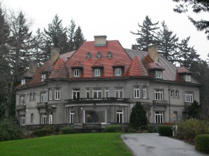
A very large and exciting dream of mine is to through-hike the Pacific Crest Trail (the 2,650 mile trail running from Mexico through to Canada), and living within short distance of it, I decided it was time to experience a small piece of this behemoth. So I set my sights out to Dry Creek Falls near Cascade Locks.

First, just in getting there, there is one important thing to note: there is summer parking, and then there is ‘rest of the year’ parking. In summer, the parking lot is literally at the last right turn before driving over The Bridge of the Gods to Washington. Before and after summer, they close off that lot. When I hiked this just a few days ago, the winter parking area was not at all obvious, and I sort of found it through dumb luck (since my trail book gave me no information on its alternate parking area). After you pull off exit 44 on 84-East, keep going about a mile until Wasco St. on your right. Drive up there and make a right turn to the dead end. That’s the winter trailhead.

When I started my trek just past the trailhead and saw the famous PCT marker nailed to a tree, I literally squealed.
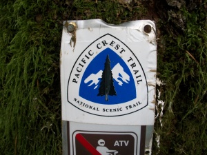
Squeeee!

It was there, I was on it, it was real! I’ve been reading countless memoirs, trail blogs, and watching all sorts of videos and documentaries about the PCT that to actually be stepping foot onto it was more exciting for me than I realized. It made knowing I was going to be through-hiking it that much more real for me. It was no longer this thing I had imagined, I was actually seeing for myself a small part of it. In a wonderfully corny way, it was magical.

There was a trail maintenance crew working to clear some of the summer overgrowth on the trail, and I just thought, ‘what a fun job!’ I assume they were likely a volunteer crew, but thought how amazing it would be to be able to make a buck working in such a beautiful environment for a living. I’ll have to look into that some day.

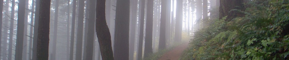
The hike out to Dry Creek Falls was very dense, lush, and straightforward. For a little more than two and a half miles, the trail gently climbs away from the Columbia River and into incredibly verdant forest thick with gorgeous old growth. It was very lovely and serene.

Perfection.

The trees were stripped of almost all autumn colors this early in winter, so the remaining forest green was abundant in the ferns, pines, and moss. It was a gorgeous trail. Finally you’ll reach an intersection with a wooden bridge stretching over Dry Creek. One would think with a name like that, the creek would be low and trickling, but it was full and roaring.

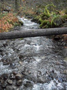
Nothing dry about this.

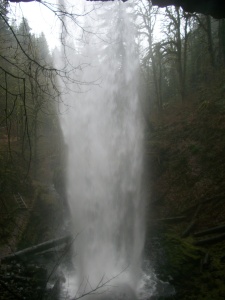
Here you have the option of continuing south on the PCT, or you can turn right up a half mile ascent to the base of Dry Creek Falls, so ascend to the falls I did. What I found was nothing short of majestic:

I mean… Wow.

Standing there at the base of this gushing beauty, it washed over me that this is just one of the hundreds upon hundreds of visual delights that await through-hikers on the PCT. It was almost too much to wrap my head around. And then a second thought came to me: one day I will be back there again, but it will have taken me over 2,000 miles and just my own two feet to reach that spot. What a dizzying thought! I also reflected on Cheryl Strayed as I sat by the falls. This was the last waterfall she experienced before ending her PCT journey at The Bridge of the Gods. The overwhelming sense for her as her trek was coming to an end, having come as far as the California Desert, I can’t imagine what she must have been feeling as she drank this vision in.

This trail is exactly what I needed, and I didn’t even know I needed it. But I did. I needed to step out onto this thing that has been floating around my head for a couple of months now and to make it real. All I felt was extreme excitement. That definitely bodes well as the next year or so of planning becomes a flurry of activity in preparation for the big trek.

This slideshow requires JavaScript.

Treks Down: 38, Treks to Go: 14

Posted in Uncategorized | Tagged , , , , , , , | 1 Comment

Trek #37: Cape Falcon

I decided to take full advantage of my weekend at the coast and hike out to Cape Falcon, touted as a gorgeous must-see to any hikers in the area. After my Neahkahnie Mountain snafu from earlier, I was looking forward to a straightforward hike out to a beautiful ocean viewpoint. And beautiful ocean viewpoint I got!


Slightly angled shot. I was a wee winded and unsteadily handed.

Cape Falcon is one of those hikes that I imagine most people take for the viewpoint alone. It’s an interesting trek in the sense that it’s the longest unbroken forested stretch of the Oregon Coast Trail (5 miles), and whilst hiking it, you feel about as far away from the ocean as possible. It’s not until you summit the hike at the tip of the cape and see infinite ocean below you that brings you back to where you actually are. It’s both breathtaking and surreal.

The trail itself, while possessing quite a few lovely spots, is just rather unbecoming. It’s incredibly, incredibly mucky. I get the impression from my trailbooks that the trail remains mucky year round. This is where I plug how amazing my Keen hiking boots are, because even when I continuously barreled through muck ankle deep, my feet were kept bone dry from trailhead to viewpoint and back. There were, however, some very slick spots that even the best traction couldn’t save, and I did wipe out once on a steep descent on wet stone. Eventually, you just embrace the fact that Cape Falcon is not going to be a clean nor graceful hike. Also, my fired “Day Hiking: Oregon Coast” trail guide says this trail has a 240 ft. elevation gain, but my fitness tracker recorded nearly 800 ft. (and confirmed by NW Explorer), so you’ll get a nice work-out in, too.

Once you reach the clearing where the tree-less viewpoint is, I recommend taking the time to explore all the corners of the small meadow. Each cliff offers a different beautiful ocean view as well as views to the coastal towns below. However, I was fighting daylight at this point and didn’t have the luxury to linger. But wow is it breathtaking up there. After you get your fill, return the way you came.

This slideshow requires JavaScript.

Treks Down: 37, Treks to Go: 15

Posted in Uncategorized | Tagged , , , , , | Leave a comment